


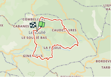
Le soulier 13 été

elexine23
User

Length
16.9 km

Max alt
998 m

Uphill gradient
390 m
Km-Effort
22 km

Min alt
856 m

Downhill gradient
387 m
Boucle
Yes
Creation date :
2022-09-23 07:23:05.961
Updated on :
2022-09-23 13:25:28.043
4h22
Difficulty : Easy

FREE GPS app for hiking
 SityTrail
IGN / Geographical institutes
SityTrail Plus
The world is yours!
About
Trail Walking of 16.9 km to be discovered at Occitania, Hérault, Le Soulié. This trail is proposed by elexine23.
Positioning
Country:
France
Region :
Occitania
Department/Province :
Hérault
Municipality :
Le Soulié
Location:
Unknown
Start:(Dec)
Start:(UTM)
474947 ; 4822120 (31T) N.
Comments